Physical Geography – including: Plate Tectonics, Earthquakes and Volcanoes; Study of Karst; The Rock Cycle; River, Glacial and Coastal processes. Meteorology and Climate Change. 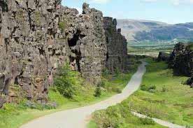
Regional Geography –- including: contrasting regions within Ireland and Europe; and study of a non-European region. 
Economic Activity – including: Ireland’s Economy and the EU; A Developing Economy; Renewable Energy, Industrial Location, Multinational Companies; Economic Activities and Conflict; Economic Activities and Environmental damage.
The Human Environment – including: Study of Population growth and density; Migration; Settlement Patterns; Land Use and Urban Use.
Model Leaving Cert. questions:
Name and explain tow difficulties that an ageing population can cause for a country. Give examples from your studies and suggest how such problems might be dealt with?
Outline two negative effects caused by colonialism on a developing country or region that you have studied. And propose some solutions to these problems.
Describe -- and explain the processes giving rise to the features of a Karst landform, as seen in Ireland.
GLACIAL FEATURES IN IRELAND
The last glaciation of Ireland caused the accumulation of ice sheets in excess of a thousand metres thick, and most of Ireland. These glaciations had a huge impact, as a result of the erosive work of slow-moving ice and also a result of depositional activity under the ice and at its margins. The ice finally retreated about 10 000 years ago.The evidence of glacial erosion is widespread in many mountain areas of Wicklow, Kerry, Conamara, North-West Donegal and North East Ulster, Corries (Irish”Coom”) are over deepened rock hollows where snow first lay, thickened and nourished ice. From these locations ice advanced into and down valleys: they were also the final station of retreating ice. Two of the most spectacular corries are the Devil's Punchbowl, on Mangerton Mountain in Co. Kerry, and Coomshingaun, in the Comeragh mountains of west Waterford, Apart from these however, there are many other such features: in west Mayo up to sixty small corries can be counted. Near Dublin, good examples are upper and lower Lough Bray; also Lough Tay, making steep rock faces that contrast artistically with the generally rounded Wicklow mountains
In lowland Ireland, there is also evidence of glacial erosion; but there is also extensive evidence of glacial deposition., Moraines are large heaps of debris pushed in front of the ice, as well as debris that was held within the moving ice sheet, and afterwards dropped as the ice waned. This latter debris now constitutes the Boulder clay that is widespread over most of lo0wland Ireland. From these clays different types of soil fertility have arisen: expending on the chemical composition of parent rock and whether the soil has since been subject to leaching by rainfall.
However, the most distinctive of all lowland topographies associated with ice are the swarms of low hills known as drumlins. These produce the Drumlin Belt that stretches from Carlingford Bay in the East to Clew Bay in the west -- where some of the drumlins have been partly submerged, and now appear as the islands of Clew Bay.
-
FEATURES OF KARST
Karst refers to a particular type of topography formed on limestone by the corrosive and erosive powers of Carbonic acid in rain water, and also ground water with a low PH due to the presence of organic acids. The process operates as follows: Ca Co3 (Calcite) +H2 Co3 (Carbonic acid) = Ca (HCo3) 2 -- which is Calcium bicarbonate. Calcium bicarbonate is soluble in groundwater -- particularly when this contains humic acid and lactic acid, due to plant decay. Karst is both permeable and pervious in nature – allowing water to percolate through its surface and through its joints and bedding planes.
The limestone of the Burren was formed during the Carboniferous period, and must have been overlain by geological deposits of later periods, which were removed by glaciation . Evidence of glaciation is seen in the presence of granite and sandstone erratics and also in the presence of stria.
It is suggested that the current area of exposed karst was initially covered by a shallow depth of soil of glacial origin. This soil would have supported a community of plants including grass, herbaceous plants and shrubs – such as hazel and hawthorn. Excess agricultural cultivation during early human settlement of this area is thought to have eroded the original soil cover – thus exposing the initial karst surface. .
Development of Karst features originates under a light soil cover because of the presence of acidic groundwater –due to the addition of humic acid produced by the decay of plant material, and the carbonic acid already present in rainwater.
The later exposure of limestone sharpened and exaggerated karst development -- due to constant exposure to carbonic acid in the persistent rainfall of Western Ireland
The main features of Karst are: (1) Flagstone pavement (clints) engraved with superficial surface channels (Lapiés); (2) These Clints are intersected by deep vertical grooves (grikes) which separate the Clints and are at right angles to the rock bedding; (3) Large erosion holes (Lapiés Wells) occurring where there is a confluence of large grikes; (4) Large solution depressions of one to several metres in dimension, and known as Turloughs – which are occupied by temporary lakes during Winter; (5) Disappearing streams, underground drainage, caves and caverns.
Over time the solution of limestone leads to the almost complete removal of Karst features from the landscape: leaving only residual steep sided limestone hills – known as hums, and also re-establishing overground (surface) drainage .
-
ORGANIC AND HYDROCARBON FUELS
-
PEAT
Through the process of aerobic respiration, decaying vegetable matter is oxidized to water and carbon dioxide. However, if plant material accumulates underwater, oxygen is not present and so only partial decomposition occurs. This incomplete decomposition over a period of time -- from several hundred to some thousands of years -- leads to the accumulation peat: an organic substance with recognisable plant remains. It contains approximately 90% water and must be dried before use. Peat burns with a long flame and considerable smoke.
As peat is buried by sediment and becomes compressed, it slowly releases water and other elements contained within it, resulting in an increasingly compact and carbon rich substance. The natural process converting plant matter to peat may go through different stages, first forming lignite, then sub bituminous coal, bituminous coal and eventually anthracite coal.
COAL BEDS consist of altered plant remains. When forested swamps died, they sank below the water level and began the process of coal formation. In general, coal forms from the remains of plants which died in prehistoric swamps and wetlands. Coal takes millions of years to develop, and has been subjected to intense heat and pressure that affected physical and chemical alterations. Different types of coal are differentiated by specific properties which result from having undergone varying degrees of heat and pressure over varying periods of time during their formation
(1) Lignite
Lignite is formed when peat is subjected to increased vertical pressure from accumulating sediments. It is the lowest ranked coal for its heat energy producing capability and carbon content. A soft, brownish coal, lignite contains the highest levels of moisture of the coal types and is known for its crumbly texture. Lignite deposits are the youngest of the coal types and have undergone the lowest intensity of heat and pressure.
(2) Bituminous Coal
Bituminous Coal -- which added pressure has made compact -- has virtually ost all traces of plant life. It is also known as "soft coal”. It is often used in industry as a source of heat energy.
(3) Anthracite is also known as "hard coal" because it is tough and has a high lustre. It has been formed as a result of combined pressure and high temperature. Anthracite burns with a short flame and little smoke
Oil and gas are called 'hydrocarbons' because they mostly contain molecules of the elements hydrogen and carbon. They form as the result of a precise sequence of environmental conditions:
• The presence of organic material
• Organic remains being trapped and preserved in sediment
• The material is buried deeply and then slowly "cooked" by increased temperature and pressure.
.Almost all oil and gas comes from tiny decayed plants, algae, and bacteria.. Oil from the North Sea is mainly found in rocks that formed during the Jurassic period - about 150 million years ago.
During this time the seas and swampy areas were rich in microscopic plants and animals. When these died they slowly sank to the bottom forming thick layers of organic material. This in turn became covered in layers of mud depositions from eroded continental crust. This trapped the organic material. and prevented aerobic respiration.
Temperatures within the Earth's crust increase with depth so that the sediments, and any plant materials they contain, warm up as they become buried under more sediment. Very slowly, increasing temperature, pressure and anaerobic bacteria started acting on the organic material. As this happened the material was slowly cooked and altered, In this was the energy first given to the plants by the sun is transferred from the organic matter and stored in crude oil and gas. As the source rock gets hotter the hydrocarbon chains within the organic matter become ever shorter – first forming crude oil, and then passing into lighter oil, and finally gas. Most North Sea Oil is the valuable light oil. Gas from the Southern North Sea is methane
Crude oil is a complex mixture of hydrocarbons with small amounts of other chemical compounds such as sulphur and nitrogen that were present in the decaying organic material and have not been removed by that process of natural refinement through increasing heat and pressure within the earth’s crust.
SOIL AND ITS CHARACTERISTICS
-
Factors of Soil Formation: Parent material, Climate, Time, Relief, Organisms and Human activity.
-
Granite as a bedrock usually produces acid soils; Basalt as bedrock produces alkaline soils; Glacial deposits of shale produce high percentage clay soils that have poor structure and give problems because of their impermeable nature. Approximately two third of Ireland has a limestone bedrock; however much of the soil covering this bedrock has been formed from boulder clay of mixed origin and much of this has been subject to leaching and gleying because of our wet climate.
In the Tropical Rainforests there is severe leaching of silica, calcium, Magnesium, Potassium and Sodium; however plant litter is produced and broken down so rapidly that the forest renews its own mineral needs; once the forest has been removed however this renewal ceases and the soil becomes quickly impoverished. Where evaporation exceeds precipitation the cation minerals such as Calcium are moved upwards to form black calcite soils called Chernozem.
Where relief is steep soil can be eroded and become thin and impoverished through constant runoff : this is particularly so where precipitation is high and ground cover is insufficient. In contrast to this the drumlin clays of Monaghan and Leitrim have heavy coverings of boulder clay that have become Gley through heavy leaching of cations and iron compounds into the B Horizon: thus producing a sticky clay texture, columnar Ped structure and impeded drainage.
Regarding time, the soils of Ireland were created from glacial debris over the past 12,000 years. Warmer climate led to growth of woodlands and this in turn added humus to the soil and redistributed minerals at different levels of the: thus the distinct zones were formed.
The important organisms within the soil, apart from plant roots are invertebrates, algae, fungi and protozoa. In the moist temperate climates the most important invertebrate is the earthworm: worms can aerate the soil through its constant burrowing, mix minerals through digestion and move up to 25 tonnes or soil particles per anum from lower regions to upper layers of the soil. Fungi and bacteria are essential to the Nitrogen and carbon cycles and thus to the breakdown of organic matter and the recycling of elements .
Man has changed soil by the felling of woodland, land drainage, ploughing, fertilising and by animal husbandry.
• Soil is omposed of minerals, dead organic matter, air, water and living organisms. Mineral matter: 45%, Water: 25%, Air:25%, Organic matter: 5%. Minerals are derived from parent rocks or glacial debris: they are absorbed from the lower horizon of the soil and recirculated by plants through water transpiration, falling leaves and ultimate decay.
• Soil Texture: This is determined by the percentages of sand, silt and clay within the soil. Coarse sand texture = 2mm, Fine sand = 0.2mm, Sand = less than .05nn, Silt = .002mm, Clay = less than .002mm.
Texture determines the permeability of the soil, i.e. its ability to retain or loose water. It also determines the soil’s facility for plant root development. Soils with a course sand texture do not retain water; thus they dry easily and only plants that have the capacity to resist drought can thrive in soil of this texture. Clay soils retain moisture against gravity, have poor aeration, become gleyed and difficult to cultivate when wet and are then prone to flooding in low-lying areas ─ such as in the Shannon basin. However, when well drained, clay soils provide good grazing land: the Macamore soils that occupy a coastal stretch from Arklow to Courtown Harbour are a good example of this type os soil. Loam is the ideal soil type for arable cultivation: it is rich in minerals and organic matter, contains a good mixture of sand and clay,retains an adequate amount of water during the normal growing seasons and allows a good development of plant roots. The rich brown soils of inland: Wexford, Carlow, Tipperary and North Cork are loams and are ideally suited to grain production; while the sandy loams of North Dublin are excellent for the production of horticultural crops.
• Structure: This refers to the platelets, clods or lumps formed in soil by the adherence of particles, assisted by clay, organic matter and moisture. The particles are called “peds” and they may accumulate into crumb, plate, column, or block structures. Columnar structure is typical of wet clay soils and this structure may impede the development of deep fibrous roots., while crumb structure is typical of loam soils, giving good aeration and allowing for the healthy development of soil organisms. Sandy soils do not form peds and therefore do not have a good soil structure. Such soil is easily eroded by wind during drought when formed on slopes.
• Water: This is important for plant development as it is the medium by which minerals are absorbed by fibrous roots and taken through the plants by the process of transpiration. Water-logging prevents soil aeration and can result in plant failure. Water is the soil is retained by two processes: adhesion and cohesion. Adhesio is the clinging of water molecules to the surface of particles. Cohesion is the clinging of water molecules to each other. These two factors give the soil particle its capillary potential. This capillary potential is greatest in small particles: thus clay particles have a high capillary potential and can retain up to 15% moisture against gravity. However, plants may not be able to obtain this moisture during great drought as too much energy may be required in the process of absorption.
Thus plant transpiration is an important factor in removing water from soil: so also is evaporation, percolation and runoff. Percolation is the downward movement of water within the soil: a process that facilitates the carrying of minerals form the upper to the lower layer of the soil. In areas of wet climate ─ such as the upland areas of Western Ireland ─ this leads to leaching andmay lead to the formation of an iron pan. Runoff can erode hillside slopes; therefore in such situations ploughing must follow the contours and only plants that give thick ground cover should be cultivated ─ such as grass.
• Aeration: The presence of air within soil is vital for plant life: plant roots require oxygen to enable them to absorb minerals from the soil, as this is work that requires energy. Oxygen is also necessary to micro-organisms involved in the breakdown in organic matter. Thus, in waterlogged soil, where aeration is negligible, organic matter remains undecomposed and in time leads to the formation of acid peat. These conditions in turn lead to the retention of Co2 ─ which is the main factor in lowering the pH level.
• Organisms ─ particularly earthworms ─ help in the process of soil aeration. Acid clay soils that are also subject to water-logging are adverse to the presence of earthworms. Such soils must be drained and fed with calcium concentrated fertilisers if they are to become productive in agriculture..
• pH of soil: This refers to the concentration of H= ions within the soil as compared to alkali ions, such as Calcium, Potassium and Magnesium. Leaching removes alkali ions and produces acid soil. The peat soils of Ireland have a pH of 4, while some of the soil pockets within the karst landscape of the Burren have a pH of 9 . A pH of 7 is said to be neutral. Slightly acid to neutral soils are best for arable farming, while many attractive garden cultivars like acid soils. On acid soils the application of lime can increase yields by 10 to 15% and will also release Nitrogen to plants from organic matter. The pH scale is logarithmic: thus pH 4 is 10 times more acidic than pH5.
• Soil Profile: Soil Profile is concerned with discrimination between defined soil horizons. Each horizon runs parallel to the soil surface but varies in colour, texture and chemical content; they also can vary in depth. Three horizons are usually defined, and are given the identifications A, B, and C. These horizons are often in turn divided into numerals 1,2,and 3.
In ideal soils Horizon A contains most organisms and organic matter; it is also the area cultivated by farming. Good soil is particularly fertile in the A1 layer, where decomposition of dead plant and animals is forming humus. Downward percolating water removes tiny clay particles, iron and aluminium oxides, plus Calcium magnesium, phosphates and potassium from the A to the B horizon. This leaching of minerals is facilitated by the water having become more acid through the dissolution of carbon dioxide and the absorption of organic acids from humus and decomposing plants. The oxides of iron and aluminium cause this layer to be darker in colour: it is the Iron oxide Fe2 O3 which gives this layer its reddish yellow colour. The percolation water tends to make the soil form a lumpy structure in the B Horizon. The C horizon is an area of poorly developed soil, and is mainly regolith from the underlying rock. This can be slowly decomposing bedrock or glacial debris.
• Humus: This is a dark substance formed by the activity of micro-organisms, invertebrates and fungi causing the breakdown of decaying plant material. It is a sticky colloidal substance, being capable of existing as a flexible gel or as a mobile solution. Humus combines with clay particles to form the clay-humus complex and this helps form the peds that become the basis of structure. This clay-humus complex possesses a negative electrical charge that attracts cations such as Calcium, Potassium and Magnesium as well as the H+ ions of Hydrogen. Thus humus absorbs recycles and makes minerals available to plant roots as well as helping to develop soil pH. Without humus formation nutrients would remain locked up within dead organic matter. Well developed humus that has been formed on grassland or deciduous forest floors is neutral to slightly acid and is called “mull”. Badly decomposed plant litter that has been formed on acid heath land or in coniferous forests is called “mor”.
• Important Soil Profiles::
(1) Brown Earth: Found in soil which has been developed in moist and cool temperate climate under deciduous woodland that have good drainage. The soil texture type is loam. There is a good crumb structure and the well developed humus is mull. The zones are well developed: the clay- humus mixture giving the A zone its dark brown colour. Water percolating downward is slightly acid and removes some iron and cations to the B horizon, which becomes reddish yellow to red through the deposition of Fe2O3 (rust) This soil is ideal for arable development and for grassland: thus most of the woodlands have been removed by man and the chemical content has been altered by the use of fertilizers..
(2) Chernozem: This is the black soil of the temperate grasslands of the Steppes of Russia and the Ukraine. The calcite humus developed from decaying organic material gives the upper horizon its black colour. Evaporation exceeds precipitation resulting in an upward pull on soil water. This in turn takes cations up to the top horizon. Thus the soil is calcimorphic ─ with excess Ca Co3 . This movement of Cations causes deposition of calcite nodules within the upper layer of the B Horizon, which is otherwise of a light brown colour.
(3) Podzol soils : This is formed in a climate of heavy precipitation underneath coniferous woodlands where the fallen foliage and plant litter forms a strongly acid “mor” humus. This humus breaks down slowly, and as conditions are unsuited to earthworms, there is poor mixing of humus with the soil beneath it: instead it lies on the surface as a black blanket, that is overlain by an undecomposed plant litter. in the A Horizon there is substantial downward leaching of all iron compounds and cations: this produces a poor grey silica soil in this upper zone, giving it a sandy texture. The B Horizon has a dark brown layer of humus deposition beneath which lies a reddish yellow soil formed from the iron compound deposition. In woodlands the roots prevent the formation of an impenetrable “Iron Pan” of a concrete-like structure; however, on heath land where deep roots are not present the “Iron Pan” becomes established ─ thus impeding further downward percolation of groundwater; thus producing land that is unsuited to agriculture. Indeed all Podzols are more favourable to afforestation than to any kind of agriculture. Podzol
(4) Latosol: a soil variety that is common to tropical or subtropical regions ─ such as Tropical Rainforests and Savannas. This soil is rich in iron and aluminium. The upper layer is dark brown and is formed from a well decomposed “Mur” humus that is slightly acid. Chemical weathering has caused the soil underneath it to become red in colour due to the presence of iron and aluminium compounds and the removal of silica. There is no distinct formation of Horizons as in the Temperate Climatic Regions.